West Rouge Community Centre 1970s

West Rouge before 1972 which is when we moved there and the pool was gone. - Posted to Facebook by my Mom.
West Rouge before 1972 which is when we moved there and the pool was gone. - Posted to Facebook by my Mom.
This was posted to Facebook by William Jossa. I lived most of my younger life in what was Port Union, or the West Rouge community.


Yes, most of the fertile land encompassing West Rouge proper was used for agriculture. Crops, orchards and a bit of mix-farming (with livestock) was commonplace.
While most of the undeveloped property in the “Rouge Hills” portion of West Rouge was owned by the C. White Company since the 1920’s; it would only make sense that they would lease out productive land to farmers, prior to redevelopment.
I’ve attached a sepia photograph of West Rouge (from the winter of 1956) where you can see the worked farmland. I also placed six markers of interest for your consideration.
I grew up in the community of West Rouge. I went to school at West Rouge Public School. I wasn't born there, we moved from the urban area of Toronto, but West Rouge is the place I remember when I think about being a kid, going to school and growing up to attend Joseph Howe Senior Public School (the first year the junior high school opened) and then Sir Oliver Mowat C.I.
West Rouge is a neighbourhood located in the city of Toronto, Ontario, Canada, in the city suburbs of Scarborough. The community is bordered by Lake Ontario to the south, the Rouge River to the east, Highland Creek to the west and Kingston Road to the north. The area was once known as the town of Port Union.
Port Union is part of the Highland Creek community. The old town lines are located in the south east corner of Lawrence Avenue and Port Union Road.
Port Union thrived as a ship-building and fishing community. The opening of the Grand Trunk Railway in 1856 started the decline of Port Union's shipping industry as the railroad industry grew. In the 1940s, Port Union returned to its nautical roots with the reintroduction of the shipping industry.
The area was settled as early as 1798, when a crown patent for lots 29, 30, 32 & 33, "Con. 1 with the Broken Front, Township of Pickering, County of York and Home District, Province of Upper Canada", were granted to William Holmes, Esquire. In 1843 Henry Cowan, an immigrant from Ayr, Scotland, bought lots 32 & 33 from Holmes and settled the land with his family. In 1848 Cowan sold a small portion of his land on the shores of Lake Ontario to the Grand Trunk Railway Company.
(As a side note, when I grew up on Rouge Hills Drive, there was a Mr. Cowan living across the street from us. So the family stayed in the area for years and years after buying the original land at least 150 years before.)
Mr. William Jackson and others purchase the piece of the shorefront south of the tracks from Henry Cowan in 1860.
A post office opened in Port Union Station in 1865. Early businesses in the area included the Scarborough, Markham, and Pickering Wharf Company (est. 1847), and hotels (Helliwell's Hotel) operated by Will Hetherington and Thomas Laskey.
Henry Cowan's son, William, buys Lot 31, on the east side of the Rouge River from Mr. John Pollock in 1868. This summer resort became known as "Rosebank".
In 1925 Dyson Craig Cowan (the son and heir of William Cowan Jr) sells "Rosebank" to the Riverside Development Company Limited (Cecil White) for the sum of $25,000
Riverside Development Company Limited changes its name to Rouge Hills, Limited. The intentions were to create a summer playground and country estates on the banks of the Rouge. The community was to be "The Venice of the North".
Summerland magazine is published by Rouge Hills Publishing Company in 1938. Summerland speaks of "The Dream and the Man Who Dreamt It".
Although the dream community didn't happen as planned, the name of White's subdivision "Rouge Hills" lives on to this day. Locals call the are "The Rouge" or "Rouge Hills". The name also lives on in the public school, GO commuter station, a shopping plaza, and a very long street (Rouge Hills Drive) which runs from the top, north of Island Road, down to the bottom, at the Rouge Beach.
In 1948, the land that is now a new housing development between Rouge Hills Dr. and Ridgewood was sold to Rouge Hills Golf and Country Club Limited. In 1973 the golf course and country club were closed. The land was abandoned and left to grow wild. Locals used it as a bike trail, walking path and so on for a long time. Eventually, it was bought up and a housing development was built on the land.
The West Rouge community was originally part of Pickering. Scarborough annexed West Rouge in 1973. The West Rouge community was east of the town line and west of the Rouge River containing 857 acres and a population of 3,414 at the time of annexation.
In 1979, fire guts Henry Cowan's old stone farm house on Rouge Hills Drive, built sometime between his purchase of the farm in 1843 and his death in 1868.
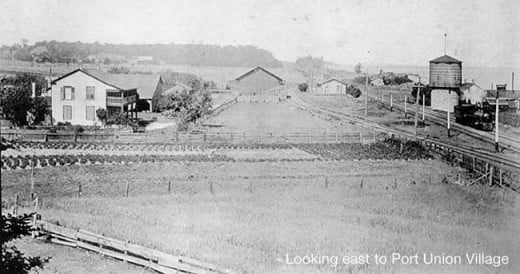 Port Union / Rouge Hills / West Rouge
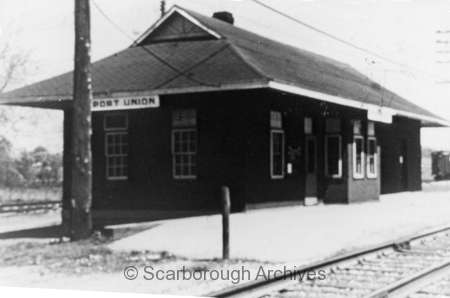 C.N.R. Railway Station, Port Union
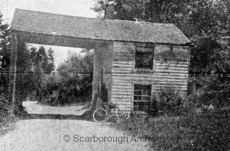 Kingston Road Toll Gate at Rouge River
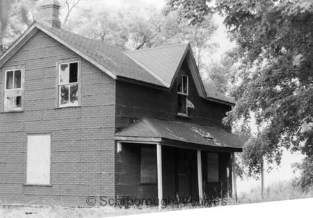 Abandoned C.N.R. Station Master's house, Port Union
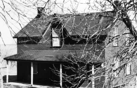 Abandoned C.N.R. Station Master's house, Port Union
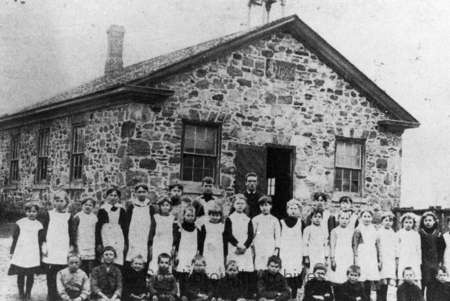 School, Port Union.
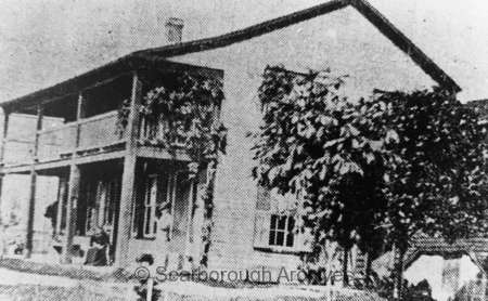 Helliwell's Hotel - Thomas Laskey's Hotel, Port Union.
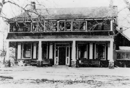 Residence, formerly Helliwell's Hotel
Port Union / Rouge Hills / West Rouge
Port Union was also part of the Highland Creek community. (Although most of the buildings were across the Town Line in Pickering.) Port Union was located in the south east corner of Scarborough, at Lawrence Avenue and Port Union Road. In 1865 a post office opened in Port Union Station. Early 19th century businesses in the area included the Scarborough, Markham, and Pickering Wharf Company (est. 1847), and hotels operated by Will Hetherington and Thomas Laskey.
In the 1920s, real estate developer Cecil White & Co. purchased multiple tracts of land east of Port Union Village with intentions of creating a large community along the west bank of the Rouge River intended to become “The Venice of the North”. Although the dream was never completely realized, the name of White’s subdivision “Rouge Hills” lives on to this day as the name of the local commuter railway station.
The West Rouge community, a modern name associated with Port Union, was originally part of Pickering. Scarborough annexed the West Rouge in 1973 following several years of negotiations. There were concerns about meshing taxation and other costs to the municipality that had to be addressed following the initial annexation discussions in 1969. The West Rouge was east of the town line and west of the Rouge River containing 857 acres and a population of 3,414 at the time of annexation.
Currently Metropolitan Toronto includes a lot of other small cities and towns. Metropolitan Toronto now reaches out to areas beyond the original borders and far beyond it's own city limits. This large mass of area has become known as The Greater Toronto Area - the GTA for short.
I grew up in a small town which was on the edge of the big city of Toronto. When I was still a kid the town was called Port Union. By the time I was in high school our town of Port Union had become part of Scarborough, absorbed into the suburbs of the city of Toronto. Scarborough is the eastern suburbs of Toronto. People sometimes refer to it as Scarberia because it is over an hour's drive from downtown Toronto to the edges of Scarborough.
I never quite liked the loss of identity from our smaller town, forgotten in history. Port Union lost it's place on the map and become a non-town. If you drive out there you can still find one long street named Port Union Road, but that's all you will find remaining from the early days of the area being independent from the suburbs of Toronto.
However, that's how big cities grow. Toronto has grown a lot from the days of being known as York (Muddy York) over 100 years ago.
The GTA combines the regions of the City of Toronto, York, Durham, Peel and Halton.
I don't live in the GTA now. I moved farther north and I live in Simcoe region, just outside the reaches of the northern part of the GTA. Someday this may become absorbed too, but I'm pretty sure that will be far into the future. Not everyone is eager to move farther north after all. Most of the population density seems to be heading east and west of the Toronto area.
In 1998 the sprawling suburbs of Toronto: York, North York, East York, Scarborough and Etobicoke became part of the municipality of the city of Toronto. The megacity, The Greater Toronto Area came into being. Toronto became the largest city in Canada and the fifth largest in North America.
The addition of Halton, Peel, York and Durham is unofficial, as far as I can tell. Sometime after the forming of the megacity people began referring to locations by how far they were from Toronto. For instance, if you were thinking to drive out to Richmond Hill from Toronto you decide it's not too far because it's still in the GTA. But, if someone is thinking to drive out to Barrie, they might rethink it. Barrie is outside the GTA, at least another half hour drive.
The whole GTA thing is usually a way of measuring the distance of any place from Toronto. "How far is it, is it still in the GTA?" When you meet people online and think about getting together there is an imaginary line around the GTA and few people want to cross it. If you are in the GTA you think anything outside of the area is too far. If you are outside of the GTA you think about driving through the GTA traffic and usually look elsewhere to meet people.