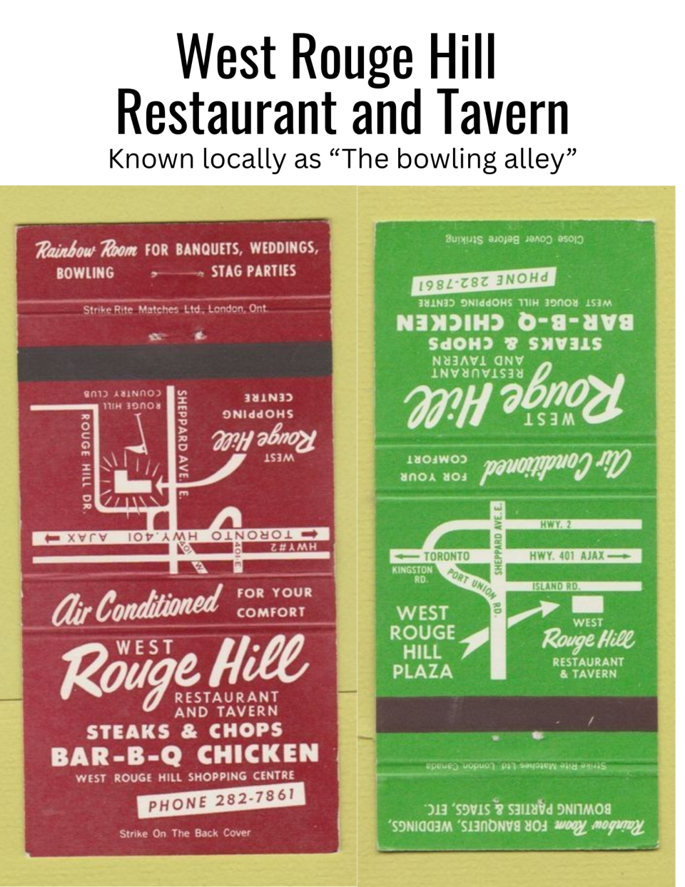
Locally we only called it "The Bowling Alley". I don't even remember it having a restaurant. It must have. My family went there for bowling, usually for family birthdays. So far I haven't found any photos of the old bowling alley online to include with the matchbook covers (found for sale online).
This includes a bit about the Johns Manville plant and an aerial photo of it. Must have been taken quite awhile ago. My brother would go there and find marbles, not really marbles but glass balls the size of marbles. Most of them had a blue tint. I don't know what they were used for, if I knew before I've forgotten. Later I attended Sir Oliver Mowat High School which was almost across the road on Lawrence Avenue East from the high school. I don't remember when Johns Manville was completely shut down. I don't think it was still in operation (not sure though) when I was in high school.
We didn't think asbestos was a big problem then. I still wonder how bad it really is when so many old houses were made with asbestos (roof and walls). I was surprised to learn Johns Manville is a US company. I never looked into it all those years we lived near it, I assumed it was a local thing, or at least Ontario. I wonder if they have already built a new subdivision or condominiums over the old site. I wouldn't be surprised, though people had claimed it could not be used for anything for a hundred years. (It hasn't been 100 years because I'm certainly not that old yet).
I never knew the full story about Thomas Adams. But we played at Adams Park often. We watched Victoria and Canada Day fireworks there. Had birthdays there (my brother especially because his birthday is in June). It had a fancy entrance with flowers and landscaping. But, I don't think we ever came through that way. There was another entrance, I forget just where now, but it was closer to the park with the sliding bridge, swings, and other recreation. My sisters and brother played soccer there too, practices and games.
 Centennial Community and Recreation Association - Centennial/ Port Union History
…more
Centennial Community and Recreation Association - Centennial/ Port Union History
…more
I found a new drawing/image of Port Union and the West Rouge area tonight. New to me. Posted to the Centennial Community and Recreation Association Port Union Waterfront Trail website, about the renovations to the waterfront awhile ago.
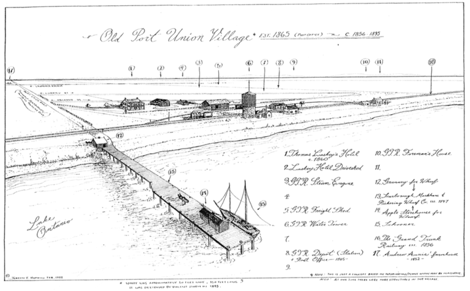
The entrance to the Centennial portion of the trail is near the former location of the Scarborough, Pickering and Markham Wharf Company’s wharf and shipping facilities operating from 1849 to 1895.
I might find that image in a bigger size to read it easier. I will try.
As I child I can remember walking along that beach until I got too tired to keep going. So, the part about not having public access in the past, seems a bit mistaken. This old wharf may be the one Toronto Boris had shown me in a photograph. Not much left of it. Too bad they have opened the beach for public consumption but have not preserved the history. Or maybe there is a plaque or something about the old wharf.
Often real estate websites have local history. I found more West Rouge and Port Union history from a few real estate sites when I tried searching today.
West Rouge
West Rouge was primarily farmland in 1926, when real estate developer Cecil White created the “Rouge Hills” subdivision. This development was intended to be a unique summer playground, with grand country estates spread out along the Rouge River. There were even plans for an elaborate canal system and private boathouses to service these estates.
“Rouge Hills” was never completed, however a few of the cottages on Rouge Hills Drive and Ridgewood Road are legacies of this subdivision. Year-round residential development of the West Rouge neighbourhood began in the 1940s, with individual lots being purchased by homeowners. Large parcels of land were subsequently developed by builders through the 1950s, ’60s and ’70s. More housing was added in the 1980s when the former Rouge Hills Golf and Country Club located in the Rouge Valley was sold to developers.
Centennial/Port Union
In the 1800s, Port Union was a booming waterfront village with thriving ship building and commercial fishing industries, two hotels, a commercial wharf, and a variety of small businesses. In 1856, the Grand Trunk Railway opened a station in Port Union which added to the importance of this waterfront village.
By 1865, Port Union’s population had reached 100 people and it was granted its own post office. The two hotels that operated in Port Union during these boom times were said to have served “knock-em stiff” whiskey and “40 Rod Whiskey”.
By the late 1800s Port Union’s shipping industry had lost most of its business to the railway and subsequently shut down. Port Union then went into a period of decline that lasted until the late 1940’s, when the return of industry to this area sparked a residential housing boom. In the 1990’s, Port Union reclaimed its waterfront with a new housing subdivision that has helped connect this neighbourhood to its illustrious past.
The area south of Lawrence Avenue is now referred to as Port Union Village. The area north of Port Union Village is now referred to as Centennial, which makes reference to the north-south street which runs through the centre of this community. Centennial Street was named after Centennial Church (circa 1891), which still stands at the north end of Centennial Road off Kingston Road. The west portion of Centennial was settled first, with larger properties and homes. By the early 1960s, Centennial East had also become a popular residential area with new homes being built steadily through the ’60s and ’70s.
Reposted from Jill's Team
These lakeshore communities lie south of Kingston Road and the 401, just west of the Rouge River and the city limits. West Rouge is the area east of Port Union Road, and Centennial (named for its main north-south street) lies between Port Union Road and the Highland Creek parklands. In the 1800s Port Union was a major port and fishing village which grew in importance in 1856 when the Grand Trunk Railway built a station, though the port declined in significance. In the 1960s the area underwent a housing boom, and in the 1980s the development of the former Rouge Hills Golf and Country Club added housing in the Rouge Valley. In the 1990s, the redevelopment of the Port Union waterfront added high density townhouses.
From Moving Canada - West Rouge & Port Union – Scarborough (Toronto) Neighbourhoods
History of West Rouge
West Rouge was primarily farmland in 1926, when real estate developer Cecil White created the “Rouge Hills” subdivision. This development was intended to be a unique summer playground, with grand country estates spread out along the Rouge River. There were even plans for an elaborate canal system and private boathouses to service these estates. “Rouge Hills” was never completed, however a few of the cottages on Rouge Hills Drive and Ridgewood Rd are legacies of this subdivision. Year round residential development of the West Rouge neighbourhood began in the 1940’s, with individual lots being purchased by homeowners. Large parcels of land were subsequently developed by builders through the 1950, 60’s and 70’s. More housing was added in the 1980’s when the former Rouge Hills Golf and Country Club located in the Rouge Valley was sold to developers.
From Sold by Shane West Rouge
This is a fairly current aerial photo of the Rouge Beach. It didn't look like this when I was a kid in the 1970's. People used to drive under the railway bridge and use the beach. There was some parking there. I can remember a little building which had a public washroom. It's still a very long beach. Though ownership has changed and I don't know if some of it is blocked off now. I do know the road going under the bridge was closed off. Now you can park on the other side.
I can see a large building on the beach side now. It was not there before. I've never seen it up close to know what it is.
On the marshy side, there is a lot more parking than there ever was before. It looks strange to see it. Before it was mainly just a dirt road with the marshy area right at the road, just a foot or so from the road. Cars would park at the side of the road, trying to leave room for other cars driving to the beach. People would go fishing in the marshy water. It used to smell like fish. I wonder if it still does, if there are any fish left. Sometimes herons would fly in too. Frogs, all those wildlife, that likely are not there now.
I don't know what year this photo was taken (Parks Canada). It must be about 2020 I'd guess.
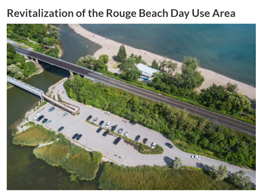
It looks like the bridge is still there, crossing from Rouge Beach into Pickering. It was not an old bridge, built about the time I was in high school, the 1980s. Or not long after that. It was at the narrow part of the water between the beach and the marshy area. It has a long ramp for disabled access which was not there when I last visited the area.